
Projects
GeoAI Empowered Environmental Studies: Rapid Wildfire Detection, Spread Modeling, and Damage Assessment with Deep Learning and Satellite Observations
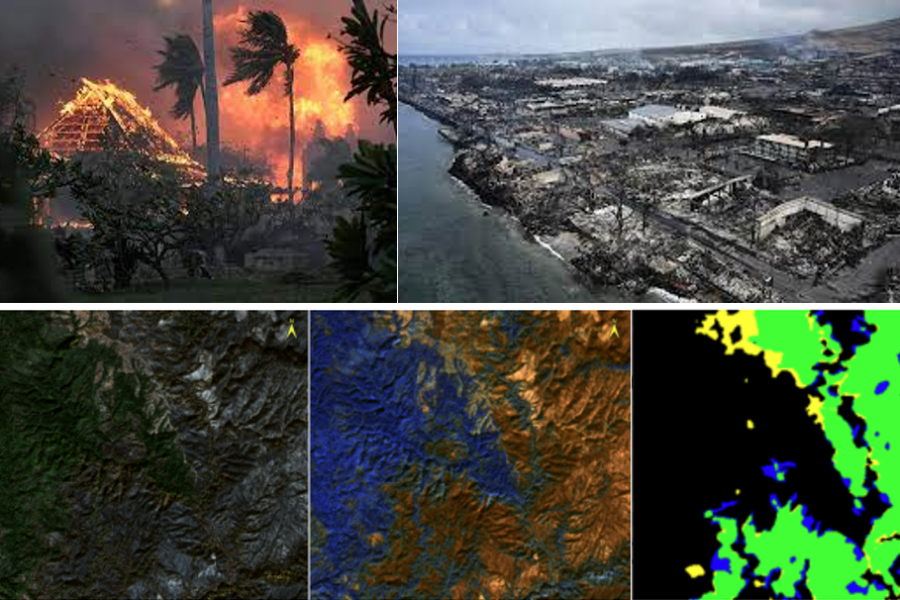
This research focuses on implementing real-time active fire detection, spread modeling, and post-fire damage assessment (scar mapping, and severity classification) with deep learning, satellite observations (i.e., GOES, VIIRS, Landsat, Sentinel), and physical models (e.g., WRF-SFIRE). contributing to more effective detection, management and mitigation of wildfire impacts and enhancing our understanding of fire dynamics. Our models aim for high accuracy and generalizability with minimal training data while generating physically realistic fire-front forecasts.

GeoAI Empowered Environmental Studies: Flood Water Depth Detection and Mapping with Camera Images and Machine Learning
This project uses photo images collected from social media and the internet to detect flood water depth and mapping. Specifically, our objective is to detect and segment common reference objects, such as humans, vehicles, buildings, lampposts, and identify the proportion of objects above and below the water, and then finally estimate the flood depth.
GeoAI to Advance Urban Informatics: Multimodal Learning for Mixed Land Use Measurement and Mapping
This research develops cutting-edge multi-modal DL models to measure and map (changes in) mixed land uses based on street view street images and urban land-use context, integrating computer vision and NLP with a self-supervised contrastive learning paradigm. Results demonstrated that our novel methodology succeeded in capturing multiple land-use functionalities of ground features accurately, and outperformed traditional vision-based single-modal DL that requires intensive supervised training.


GeoAI to Advance Urban Informatics: Deep Learning for Urban Neighborhood Perception Measurement and Prediction
This research employs big image data and deep learning to measure and predict urban neighborhood indicators like safety, livability, playability, walkability, depression, and wealthiness. One of our recent works uses Google Street View images and the Swin Transformer for predicting the socioeconomic status of urban neighborhoods.
Activity Knowledge Discovery: User Profiling with Statistical Modeling and Machine Learning
This project aims to infer user demographics (e.g., ethnicity), socioeconomic status (e.g. income), and interests (e.g., occupation) from travel trajectories, enabling the examination and interpretation of movement patterns, social inequality, interaction and segregation among different population groups.

Mobility Pattern Mining and Analytics
This research models and analyzes human daily movements, representative daily trajectory, frequent trajectory pattern, next visiting location, and urban mobility patterns, with broad applications in optimizing business site selection, enhancing targeted advertising, improving disease control strategies, refining urban planning, advancing transportation systems, and beyond.


GeoAI Empowered Environmental Studies: Near Real-time Flood Mapping with Deep Learning, Computer vision, and Remote Sensing
This project integrates data from both physical sensor networks (e.g., remote sensing, and UAVs), and citizen sensor networks (e.g., social media and citizen contributed data through a developed mobile app), with advanced artificial intelligence (AI), computer vision and spatial analysis techniques to assess flood damage.
GeoAI Empowered Environmental Studies: Social Sensing and Machine Learning for Situational Awareness
This project leverages social media datasets, natural language processing, and deep learning technologies to extract useful information for establishing situational awareness (SA), performing damage assessment, and informing decision making during natural hazards. In particular, our recent works largely advanced the capabilities of automatic extraction and classification of informative messages through a self-supervised learning framework built on a large-scale pre-trained model, an unsupervised learning with guided latent Dirichlet allocation (LDA) approach , and multi-modal learning that fuses both textual and visual features from social media data.

GeoAI to Advance Urban Informatics: Image Geo-localization via Multi-modal Learning
This research investigates multi-modal DL as a stand-alone solution to city-level image geo-localization based on salient visual features from street view images. Results demonstrated that our proposed zero-shot and linear-probing models (i.e., geo-contextualized prompt tuning on the contrastive language-image pre-training (CLIP) model and linearly training CLIP’s image encoder) outperformed the state-of-the-art model with significant accuracy improvements on different large-scale benchmark datasets, including worldwide 22k street view images.


Digital and Sustainable Agriculture: Crop Mapping, Growth Monitoring, Yield Predication, and Visualization
This project develops models and tools to offer near real-time, in-season crop type mapping, crop growth monitoring, and yield prediction using state-of-the-art remote sensing and deep learning technologies. We also develop a web-based cyber-platform for modeling, output visualization, and dissemination, utilizing cloud computing technologies.
Activity Knowledge Discovery: Travel Activity Type Inference with Machine Learning
This project infers the activity types or semantic information (e.g., dwelling, working, shopping, eating, entertainment) at individual’s frequently visited locations, enabling the analysis and understanding of people’s travel patterns and travel demands, from raw trajectory datasets collected by social media platforms, mobile phones, and GPS. More details >>

Social/Environmental Justice and Measurement
Building on our efforts in mobility pattern analytics, this research develops spatial statistical models and novel spatial indexes to quantitatively measure individual experienced segregation, resource access inequality, and environmental justice, incorporating individual-level trajectory data and considering activity space beyond residential location.

Honors, Awards and Scholarships Received by Lab Members
- H.I. Romnes Faculty Fellow: Qunying Huang (2024)
- Elsevier Top 2% Scientists List (by Stanford University): Qunying Huang (2022)
- Vilas Mid-Career Investigator Award: Qunying Huang (2022)
- Microsoft AI for Earth Award: Qunying Huang (2020)
- Madison Teaching and Learning Excellence Faculty Fellow: Qunying Huang (2016)
- The 1st International Symposium on Spatiotemporal Computing Best Paper Award: Qunying Huang (2015)
- Next Generation of Hazards & Disasters Researchers, National Science Foundation: Qunying Huang (2014)
- CyberGIS Fellow, NCSA, University of Illinois at Urbana-Champaign IL: Qunying Huang (2014)
- Outstanding Graduate Student, George Mason University: Qunying Huang (2012)
- Student Best Paper Travel Award, UCGIS: Qunying Huang (2011)
- AAG CISG Student Best Paper Award: Qunying Huang (2010)
- Presidential Scholarship, George Mason University: Qunying Huang (2007- 2010)
- Graduated with Honor, Central South University : Qunying Huang (2004)
- Best Undergraduate Thesis, Central South University: Qunying Huang (2004)
- AAG- Remote Sensing Specialty Group: Tang Sui (2025, Student Paper Competition Finalist); Bo Peng (2020, Student Poster Competition Finalist, competition canceled due to COVID-19 )
- CaGIS Map Design Competition: Atlas Guo (2025, Honorable Mention of David Woodward Digital Map Award; 2023, Best Print Map; 2021, Honorable Mention)
- Wisconsin Land Information Association (WLIA): Atlas Guo (2025 1st Place in Thematic Map, 1st Place in Black & White Map, 2nd Place in Reference Map, 2nd Place in Mapping Poster, Best Student Map (sole); 2024 and 2021, Best Student Map; 2024, 1st Place in Most Unique Map, 1st Place in Black & White Map, 2nd Place in Thematic Map, Keynotes Choice of Static Map (sole), President’s Choice (sole); People’s Choice (sole))
- UW-Madison Commencement Flag bearer of College of Letters & Science for the Doctoral, MFA, and Medical Professional Degree Candidate Ceremony: Meiliu Wu (2024)
- UW-Madison: Meiliu Wu (2024, Capstone Teaching Award)
- American Association of Geographers (AAG) Student Travel Award & Grant: Meiliu Wu (2024, $500; 2023, $500; 2022, $300)
- AAG Travel Grant for Geospatial Cyberinfrastructure Workshop: Meiliu Wu (2024, $650)
- Association of Geographic Information Laboratories in Europe (AGILE) Student Grant: Meiliu Wu (2024, $1,000)
- Iowa State University GIS Day: Atlas Guo (2025, Winner (sole) in Map Category, Mapping Masterminds Competition)
- British Cartographic Society: Atlas Guo (2024, Highly Commended, Collins Bartholomew Award for Thematic Mapping & Infographics, 2nd place; 2024, Commended, Garsdale Design Award for 3D Mapping, 4th Place)
- Arizona Geographic Information Council: Atlas Guo (2024, Winner of Student Project, 1st place)
- North American Cartographic Information Society (NACIS) Conference: Atlas Guo (2024, Winner in Research Map, 1st place; 2023, Best Cartographic Design Award)
- GIS Colorado: Atlas Guo (2024, GISCO Mapping Contest, 1st place of Student Artistic Section)
- AAG-CyberInfrastructure Specialty Group (CISG): Bo Peng (2011, Finallist), Meiliu Wu (2023, 1st, $300)
- AAG-Geographic Information Science and Systems (GISS) Specialty Group: Meiliu Wu (2023, 2st, $450)
- University Consortium for Geographic Information Science (UCGIS), Meiliu Wu (2023, Student Best Paper); Atlas Guo (2024, scholarship travel award)
- UW-Madison Annual Digital Salon: Atlas Guo (2024, 2nd Place (tie) / Honorable Mention; 2023, 2nd Place / Honorable Mention)
- AAG- Spatial Analysis and Modeling (SAM) Specialty Group: Meiliu Wu (2022, 2st, $450), Atlas Guo (2021, Travel Award)
- AAG- Hazards, Risks, and Disasters Specialty Group: Bo Peng (2021, Best Paper), Mingda Wu (2023, Best Paper)
- American Society for Photogrammetry and Remote Sensing (ASPRS) William A. Fischer Memorial Scholarship: Bo Peng (2020, $2000)
- Applied Machine Learning Summer Research Fellowship, Los Alamos National Laboratory: Bo Peng ( 2020, $14,600)
- ACM SIGSPATIAL Travel Grant: Songxi Yang (2024, $1000), Meiliu Wu (2022, $1000), Bo Peng (2019, $1000), Zonglin Meng (2019: $1000)
- International Conference on Geoinformatics Best Student Competition: Meiliu Wu (2021, 2st, $500)
- International Graduate Workshop on GeoInformatics Best Participation Award: Meiliu Wu (2021)
- Esri User Conference: Atlas Guo (2024, Most Innovative Map, 1st place; 2024, Best Cartography Award; 2024, Cartography Special Interest Group Excellence Award; 2024, 1st Place of Student Maps; 2023, Most Innovative Map, 1st place; 2023, Cartography Special Interest Group Excellence Award; 2020, Top 2 ranked maps out of 600+ submissions)
- Geography, UW-Madison: Xinyi Liu (2018, Petchenik Graduate Award), Bo Peng (2021, Olmstead Award for Outstanding Publication; 2019, Graduate Student Research Grant), Xinyi Liu (2021, Whitebeck Graduate Dissertator Award, $11,000), Meiliu Wu (2021-2024, Trewartha/Odebolt Graduate Research & Travel Award, $4000)
Grants
- 2023: Developing a GeoAI Foundation Model for Global Flood Extent Mapping, PAII Inc Research Lab. 1/1/2024 – 12/31/2024, $50,000/yr. PI: Qunying Huang
- 2023: Potential Impact of Florida SB264 – Agricultural Land, Critical Infrastructure and Military Installation Zone Mapping and Analysis, Chinese American Legal Defense Alliance (CALDA), 5/1/2024 – 6/15/2024, $4680. PI: Qunying Huang
- 2022: DSFAS-AI: Developing an Integrated Deep Learning Modeling Framework for County-Level Crop Yield Prediction in support of USDA NASS Operation, National Institute of Food and Agriculture, 1/1/2022 – 6/1/2024, $649,786 (Co-PI). PI: Dr. Zou Zhang
- 2020:Fusing Social Media Data and GeoAI for Disaster Event Detection, Vilas Mid-Career Investigator Award, UW-Madison, 6/1/2020 – 6/1/2022, $89,272. PI: Qunying Huang
- 2020: Self-Supervised Deep Learning and Computer Vision for Real-Time Large-Scale High Definition Flood Extent Mapping, Microsoft AI for Earth Grant, Microsoft, 6/1/2020 – 6/1/2022, $30,000 (Co-PI). PI: Bo Peng
- 2019: CoPe EAGER: Collaborative Research: A GeoAI Data-Fusion Framework for Real-Time Assessment of Flood Damage and Transportation Resilience by Integrating Complex Sensor Datasets, National Science Foundation, 1/1/2020 – 1/1/2022, $299,709. PI: Qunying Huang
- 2019: Contextualized Daily Prediction of Lapse Risk in Opioid Use Disorder by Digital Phenotyping, National Institute of Health, 8/1/2019 – 6/30/2024, $3,416,728 (Co-PI). PI: Dr. John Curtin
- 2017: Risk-based Assessment and MANagement (RAMAN) Online Visualization Tools for Health of Bluff, Beach, and Nearshore Environments on Wisconsin’s Coast, NOAA Sea Grant, 02/01/2019 – 02/01/2021, $142,000 (Co-PI). PI: Dr. Chin Wu
- 2017: A 3D Visualization System for Human Mobility Study Using Online Footprints, Wisconsin Alumni Research Foundation (WARF), 04/01/2018 – 06/30/2019, $39,270. PI: Qunying Huang
- 2016: EPIGRIDS: Electric Power Infrastructure and Grid Representation in Interoperable Data Sets, Department of Energy, 08/10/2016 – 11/09/2019, $1,476,000 (Co-PI). PI: Dr. Christopher L. DeMarco
- 2016: Resource Demand Estimation for Effective Disaster Response Using Crowdsourcing Data, WARF, 09/01/2017 – 09/01/2018, $46,765. PI: Qunying Huang
- 2015: Evaluation of Big Data Containers for Popular Storage, Retrieval, and Computation Primitives in Earth Science Analysis, National Aeronautics and Space Administration (NASA), 06/01/2015 – 06/01/2017, $50,000. PI: Qunying Huang
- 2015: Developing an Intelligent System for Disaster Situational Awareness Based on Social Media, WARF, 07/01/2015 – 06/30/2016, $31,979. PI: Qunying Huang
- 2014: Developing a Cloud-enabled Interactive Mapping System for Wisconsin Economic Development Corporation (WEDC), WEDC, 06/01/2014 – 06/01/2015, $10,000 (Co-PI). PI: Dr. Howard Veregin
- 2012: ESIP Testbed: Cloud Cost Model, Federation of Earth Science Information Partners (ESIP), 09/01/2012 – 08/30/2013, $5000. PI: Qunying Huang
- 2011: Cloud Enable GEOSS Clearinghouse, Microsoft, 06/01/2011 – 05/30/2012, $100,000 (Co-PI). PI: Dr. Chaowei Yang
- 2010: Geospatial Cloud Processing, ESIP student funding, 09/01/2010 – 08/30/2011, $3000. PI: Qunying Huang
- 2009: GeoCloud Initiative, Federal Geographic Data Committee (FGDC), 09/01/2009- 08/30/2010, $30,000 (Co-I). PI: Dr. Chaowei Yang


![]()

![]()


![]()
![]()