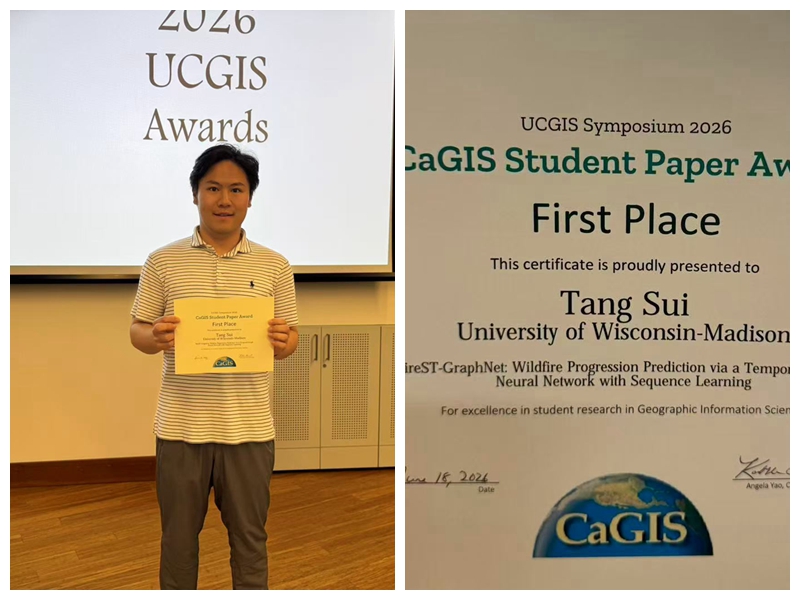
Congratulations to Tang Sui on Winning First Place in the 2026 UCGIS Student Paper Competition with FireST-GraphNet!
June 18, 2026
A huge congratulations to Tang Sui for winning First Place in the CaGIS Student Paper Competition, presented at the 2026 UCGIS Symposium!
🥇 Award-winning paper: FireST-GraphNet: Wildfire Progression Prediction via a Temporal Graph Neural Network with Sequence Learning
Outstanding work, Tang! We are incredibly proud of this well-deserved achievement and look forward to your continued success! 👏🔥
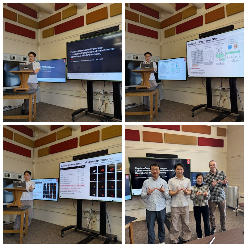
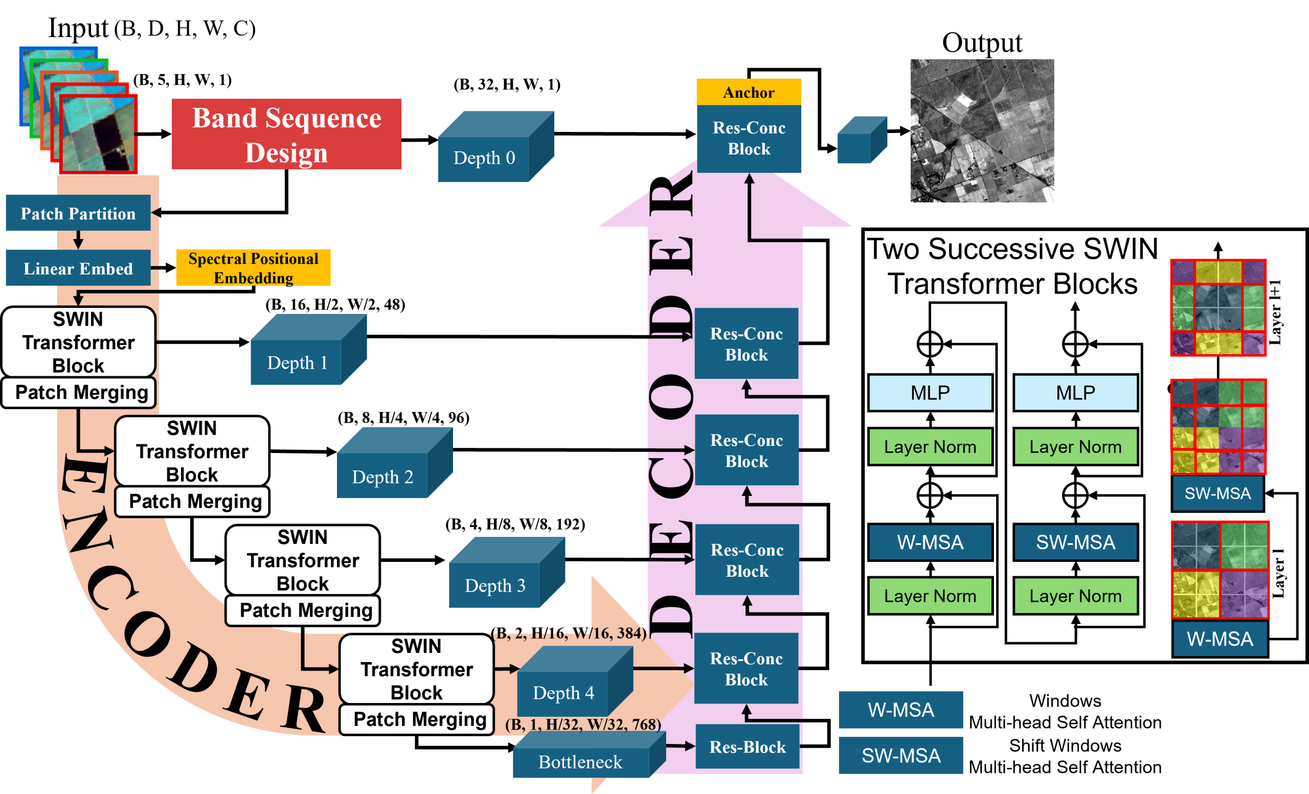
🎓 Student Milestone: Tang Sui Successfully Defends His M.S. Thesis on Operational Wildfire Modeling
May 1, 2025
Congratulations to Tang Sui on successfully defending his M.S. thesis:
“Physics-Constrained Forecast-Conditioned Graph Neural Networks for Operational Wildfire Modeling.”
Many thanks to his committee members, Dr. Song Gao and Dr. Paul C. Stoy (Biological Systems Engineering), everyone who attended the public defense, and the faculty, colleagues, and friends whose support made this achievement possible.
Tang will continue his Ph.D. in our department, advancing research at the intersection of remote sensing, GeoAI, and machine learning for Earth observation.
Congratulations, Tang, on this milestone! As one committee member remarked, “This is comparable to Ph.D.-level work.” We look forward to seeing your future contributions!
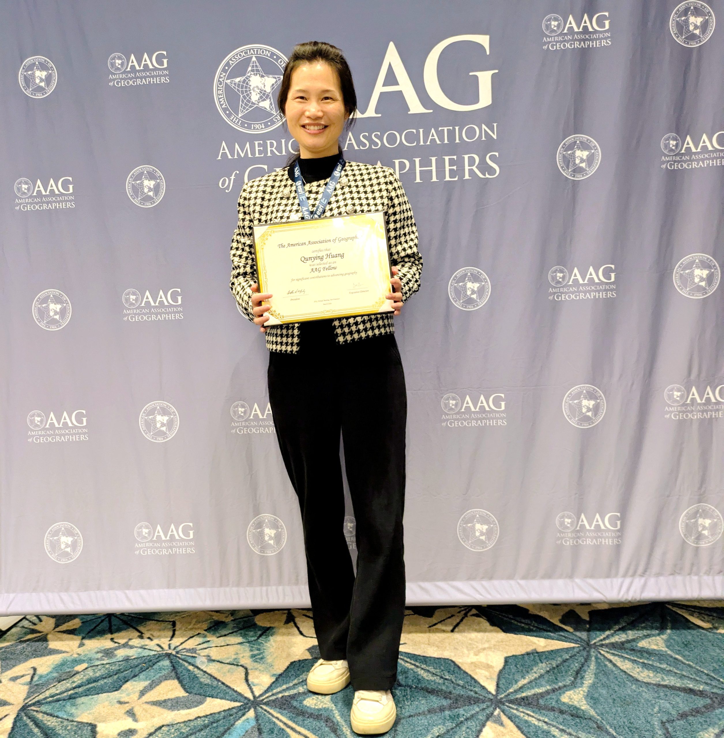
Dr. Qunying Huang Honored as AAG Fellow
March 20, 2026
Congratulations to Dr. Huang on being named a Fellow of the American Association of Geographers (AAG), an honor that acknowledges geographers who have made meaningful contributions to advancing the discipline. This year, Dr. Huang is one of twelve geographers worldwide to receive this recognition. The AAG Fellows program highlights the dedication and service of geographers in research, teaching, and community engagement. Dr. Huang is deeply humbled by this recognition and grateful for the support of her colleagues, mentors, and the broader geography community, whose guidance and collaboration have been invaluable throughout her career.
🌟Student Research Milestone: Tang’s New Publication on AI-Powered Hyperspectral Imagery Generation
Feb 09, 2026
A long-standing challenge in remote sensing is the spatial–spectral trade-off: multispectral imagery provides high spatial resolution but limited spectral detail, while hyperspectral imagery offers rich spectra at lower spatial resolution. To address this challenge, Tang developed SpecSwin3D, a novel 3D SwinUNETR-based transformer that generates hyperspectral imagery from multispectral data by learning complex spectral relationships while preserving fine spatial details. The model achieves a Peak Signal-to-Noise Ratio (PSNR) of 35.84 dB, Spectral Angle Mapper (SAM) of 2.39°, and Structural Similarity Index (SSIM) of 0.96, outperforming state-of-the-art deep learning approaches by +5.8 dB in PSNR while reducing Relative Dimensionless Global Error in Synthesis (ERGAS) by more than half. These advances represent a significant step forward in high-fidelity hyperspectral imagery reconstruction.
Congratulations, Tang, on this outstanding achievement! Your work pushes the frontier of AI-driven hyperspectral imagery generation and opens new opportunities for low-cost hyperspectral data for geospatial applications. 🚀
Reference:
Sui T. Yang S., and Huang Q.*, 2026. Generating Hyperspectral Imagery from Multispectral Data via Transformer Networks and Curriculum-Based Cascade Training. IEEE Transactions on Geoscience and Remote Sensing, 64: 1-13. DOI: 10.1109/TGRS.2026.3662323.
🌟Student Research Milestone: Songxi’s Publications on Remote Sensing Super-Resolution for Earth Observation
Nov 26, 2025
Coarse spatial resolution remains a fundamental limitation in many remote sensing (RS) applications. Addressing this challenge, Songxi developed GeoAwareDiffSR, a novel geospatial-aware remote sensing super-resolution (RSSR) framework that integrates diffusion priors with multispectral remote sensing characteristics and domain-specific geospatial knowledge. Extensive experimental evaluations demonstrate significant improvements in crop boundary delineation and structural recovery, highlighting the framework’s strong methodological rigor and applied relevance.
This research builds upon Songxi’s comprehensive review of 124 prior studies in remote sensing super-resolution, resulting in a foundational review article that synthesizes recent advances in remote sensing single-image super-resolution, identifies key challenges, and outlines promising future research directions for the field.
Congratulations, Songxi, on these publications and for your contributions to advancing an important and emerging research direction within our lab and the broader remote sensing community!
Reference:
Yang S., Sui T. and Huang Q., 2025. GeoAwareDiffSR: geospatial-aware remote sensing super resolution with diffusion priors and multi-modal constraints for crop mapping. GIScience & Remote Sensing, 62(1), p.2597564. Full Paper
Yang S., Ebrahimian H., Zhang Z., and Huang Q. (2025). Deep learning for single-image super-resolution in remote sensing: A review. International Journal of Remote Sensing, 1–43. Full Paper
🌟Student Milestone: Yang (Eric) Qiu (Computer Science Undergraduate) Publishes First Leading-Authored Journal Paper on Integrating Street View Images and Multi-task Learning for Urban Perception Prediction
Jan 17, 2025
Using 110,988 street view images from 56 cities worldwide, we developed deep learning models based on the Swin Transformer and Multi-gate Mixture-of-Experts (MMOE), a multi-task learning architecture, for urban wealthiness predication.

Congratulations, Eric, on publishing your first journal paper as the leading author!
Reference:
Qiu Y., Wu M., Huang Q. and Kang Y., 2025. Do You Know Your Neighborhood? Integrating Street View Images and Multi-task Learning for Fine-Grained Multi-Class Neighborhood Wealthiness Perception Prediction. Cities, 158, p.105703. DOI: https://doi.org/10.1016/j.cities.2025.105703
🌟Student Milestone: Tang Sui (Undergraduate) Publishes First Leading-Authored Journal Paper on Wildfire Burnt Area Mapping with Remote Sensing and Deep Learning
9 July 2024

Tang’s paper introduces BiAU-Net, a novel U-Net-based model that incorporates attention mechanisms and a specialized loss function to significantly enhance the mapping of wildfire burnt areas. The model improves the detection of edges and small burnt regions, setting it apart from traditional single-input U-Net models. BiAU-Net leverages pre- and post-fire Sentinel-2 imagery as dual inputs, capturing temporal changes and boosting performance across diverse environmental conditions. The study’s approach was tested on five independent areas from different continents, demonstrating the model’s generalizability and potential for broader applications in remote sensing.
Congratulations, Tang, on publishing your first journal paper as the leading author!
Reference:
Sui T., Huang Q.*, Wu MD., Wu ML. and Zhang Z., 2024. BiAU-Net: Wildfire burnt area mapping using bi-temporal Sentinel-2 imagery and U-Net with attention mechanism. International Journal of Applied Earth Observation and Geoinformation, 132, p.104034. DOI: 10.1016/j.jag.2024.104034
Lab team at Agile 2024 conference, and UCGIS+CaGIS 2024 Symposium
June 15, 2024
Dr. Huang presented our recent work on social media user profiling with multimodal learning based on tweet messages and Google Street View imagery at Agile 2024, in Glasgow, UK, June 4-7, 2024.
Liu X., Peng B., Wu M., Wang M., Cai H. and Huang Q.*, 2024. Occupation Prediction with Multimodal Learning from Tweet Messages and Google Street View Images. In Proceedings of 2024 Agile Conference, June 4-7, 2024, Glasgow, UK, pg.1-6. Slides
Congratulations to Atlas for receiving the ICA Scholarship for his work on multimodal social media data learning and visualization for hurricanes, at the 2024 CaGIS+UCGIS Symposium in Columbus, OH, June 3-6, 2024!

🌟Student Milestone: First paper published by Songxi (First-year Ph.D) on Remote Sensing for Active Fire Detection
June 12, 2024

Yang, Songxi, Qunying Huang, and Manzhu Yu. Advancements in remote sensing for active fire detection: a review of datasets and methods. Science of the total environment (2024): 173273. DoI: https://doi.org/10.1016/j.scitotenv.2024.173273

Congratulation to Meiliu, and Yutong on their graduation!
Congratulations, Dr. Wu and Yutong, B.S.! This is such an exciting milestone in your lives. Wishing you both a bright and fulfilling journey ahead!
🎓Student Milestone: Meiliu Wu successfully defended her Ph.D dissertation and will be joining the faculty at the University of Glasgow!
April 8, 2024
Big congratulations to Meiliu who successfully defended his dissertation, titled “Towards GeoAI Foundation Models: A Multimodal Learning Framework with Spatial Knowledge”.
Many thanks to the committee members, Drs Song Gao, Zhou Zhang (Biological Systems Engineering), and Yong Jae Lee(Computer Sciences) as well as audiences joining the public talk in person or virtually!
Meiliu will start a new chapter of her career as the Lecturer (Tenure-track Assistant Professor) of geospatial data science, at the University of Glasgow this July, educating the future workforce of spatial thinkers and spatial data scientists!
Once again, congratulations, Dr. Wu! We are so proud of what you have achieved here at UW-Madison Geography, wish all the best for your new adventure, and look forward to your continued success in this exciting journey!

Congratulations for Atlas for Wining the 2024 WLIA MAP Contest Awards

Congratulations to Atlas winning seven awards for maps submitted to the Wisconsin Land Information Association (WLIA) map contest, held during the association’s annual conference in Green Bay from February 27 – March 1, 2024. Our winning entries encompass a diverse range of creations, including one digital map entitled Ancient Chinese Style Basemap Design, two print maps: The United States of Natural Disasters and Overview Map of Lifetime Footprint in Memory of Grandfather, and a special format map: the LEGO Map of Wisconsin.
For more details, please go to our department news page, and WILA news page!
Congratulation, Atlas! We are so proud of you!!

Congratulations to Meiliu for receiving the Capstone Teaching Award!
March, 12, 2024
“I believe that education should focus on student-centered learning,” Meiliu said. “As a passionate educator, I am committed to guiding students on a path of discovery, innovation, and empowerment. I am devoted to inspiring the next generation of geospatial data science professionals to engage with various geospatial applications.”
Congratulation, Meiliu! I genuinely believe that you are an amazing educator, preparing the future workforce of spatial thinker, and spatial data scientists!!

Congratulations to Atlas for receiving the Best Cartographic Design at the NACIS Conference!
Oct 13, 2023
Congratulations and well done, Atlas! You've once again demonstrated your talent, creativity and skill in map design! !
Congratulations to Mingda (Undergraduate) for receiving the Best Presentation Award at the ICBDT 2023 conference and for publishing the first lead-author paper!
Sep 23, 2023
Wu M.D., Huang Q., Sui T., Wu M.L., Pixel-wise Wildfire Burn Severity Classification with Bi-temporal Sentinel-2 Data and Deep Learning. In Proceedings of the 6th International Conference on Big Data Technologies (ICBDT 2023) Conference, Sep 22-24, 2023, Qingdao, China, pg.1-6. (Under publication) Paper Slides

Huge congratulations, Mingda! You’ve achieved remarkable progress in your research over the past year! Keep up the great work!

Congratulations to Meiliu on the UCGIS Student Paper Competition Award (First Place)!
June 8, 2023
Meiliu Wu won the first place of student paper competition awards during her first attendance at the University Consortium for Geographic Information Science (UCGIS) symposium! Bravo, Meiliu! Your achievement is truly outstanding!
Competition paper: “Measuring Access Inequality in a Hybrid Physical-Virtual World: A Case Study of Racial Disparity of Healthcare Access During CoVID-19”

Congratulation to Boyuan and Yang on their graduation!
May 16, 2023
Congratulations, Boyuan and Yang, on your well-deserved graduation! Boyuan graduates with honor and will be taking his academic journey to the next level by pursuing a Master's degree in Computer Science, at UW-Madison, with the added distinction of funding. Similarly, Yang has received numerous offers and has decided to continue his graduate study within the Computer Science department, at UC San Diego.
Congratulations once again, Boyuan and Yang, on this significant milestone in your lives. Best wishes for a prosperous and fulfilling journey ahead!
Congratulations to Atlas and Meiliu on their student competition awards!
April 1, 2023
Chenxiao (Atlas) Guo won the Arther Robinson Award (Best Print Map) at the 50th Annual CaGIS Map Design Competition!
Award Map: Visualizing Historical Hurricanes in the Continuous United States (1851-2021)
Meiliu Wu won TWO student paper competition awards from the CyberInfrastructure Specialty Group (CISG), and the Geographic Information Science and Systems (GISS) Specialty Group at AAG!
CISG award paper: “Vision-Language Multimodal Learning for Mixed Land Use Measurement and Mapping with Street View Images.” (1st place)
GISS award paper: “Revealing Racial-Ethnic Segregation with Individual Experienced Segregation Indices Based on Social Media Data: A Case Study in Los Angeles-Long Beach-Anaheim” (2nd place)
Well done! Atlas and Meiliu!
New Publication on Vision Language Multi-modal Learning Led by Meiliu: IM2City: image geo-localization via multi-modal learning
Sep 21, 2022
Reference:
Wu, M. and Huang, Q., 2022, November. IM2City: image geo-localization via multi-modal learning. In Proceedings of the 5th ACM SIGSPATIAL International Workshop on AI for Geographic Knowledge Discovery (pp. 50-61). Download
New Publication on Scientific Report Led by Xinyi: Graph Neural Networks for Individual Travel Activity Inference
Aug 29, 2022
Reference:
Liu X., Wu M., Peng B., and Huang Q., 2022. Graph-based representation for identifying individual travel activities with spatiotemporal trajectories and POI data. Scientific Report. DOI : 10.1038/s41598-022-19441-9. Download
More details >>Activity knowledge discovery: Modelling and unfolding activity space and types of social media and mobile users

Congratulation to Bo, Jamp and Yuehan on their graduation!
May 16, 2022
Congratulations, Bo, Jamp, and Yuehan! Your graduation is just the beginning of an exciting adventure in your life. Here's to a future filled with boundless success, constant growth, and unending fulfillment!
🌟Student Milestone: Vicky (Senior) and Boyuan (Junior) had their first lead-author paper accepted
April 4, 2022
Vicky: Tianhui (Vicky) Cai, Hongyu Gan, Bo Peng, Qunying Huang, Zhiqiang Zou, 2022. Real-time Classification of Disaster Images from Social Media with a Self-supervised Learning Framework. IEEE International Geoscience and Remote Sensing Symposium (IGARSS), 17 – 22 July, 2022, Kuala Lumpur, Malaysia.
Boyuan: Boyuan Zou, Bo Peng, Qunying Huang, 2022. Flood Depth Assessment with Location-Based Social Networks Data and Google Street View — a Case Study with Buildings as Reference Objects. IEEE International Geoscience and Remote Sensing Symposium (IGARSS), 17 – 22 July, 2022, Kuala Lumpur, Malaysia.
Congrats, Vicky and Boyuan!
New Grant from USDA: Developing an integrated deep learning model framework for county-level crop yield prediction
March 18, 2022
Collaborating with Drs. Zhou Zhang (UW-Madison, PI) and Zhengwei Yang (USDA NASS, Co-PI), Dr. Huang (Co-PI) recently received funding for a project titled “DSFAS-AI: Developing an integrated deep learning model framework for county-level crop yield prediction in support of USDA NASS operation” through NIFA AFRI’s Data Science for Food and Agricultural Systems program. It was among 13 projects selected to share $7 million in funding.
Student Achievement: Meiliu (1st year Ph.D) won John Odland student paper competition, SAM, AAG
Feb 26, 2022
Congratulations to Meiliu, who won the John Odland student paper competition, hosted by the Spatial Analysis and Modeling specialty group of the AAG annual meeting.
In Nov, 2021, Meiliu also won the CPGIS Student Paper Competition, on the 28th International Conference on Geoinformatics.
Meanwhile, Meiliu had her first lead-author paper published this Jan.
Wu, M. and Huang, Q., 2022. Human movement patterns of different racial-ethnic and economic groups in US top 50 populated cities: What can social media tell us about isolation?. Annals of GIS, pp.1-23. DOI: 10.1080/19475683.2022.2026471. Download
Keep it up, Meiliu!
🎓Student Milestone: Bo Peng successfully defended his Ph.D dissertation!
Dec 10, 2021
Big congratulations to Bo who successfully defended his dissertation, titled “Geography Informed Machine Learning for Remote Sensing of Disasters: A Case Study of Floods”. Next, Bo will start a new chapter of his career at the PAII Inc as a Senior Research Scientist in CA, continuing the work of leveraging GeoAI, Computer Vision and Remote Sensing for Social Goods! Well done, Dr. Peng!

New Publication on IJDE: Situational awareness information extraction with Geographic context-aware text mining
August 31, 2021
Reference: Scheele C., Yu M. and Huang Q., 2021. Geographic context-aware text mining: enhance social media message classification for situational awareness by integrating spatial and temporal features. International Journal of Digital Earth, pp.1-23. DOI: https://doi.org/10.1080/17538947.2021.1968048. Download
Hiring: 3~4 student hourly positions for remote sensing data annotation and processing
Feb 12, 2021
We are seeking several hourly students to help annotate (label) a set of satellite imagery for the research of AI for Earth Observation. The responsibilities will include interacting with researchers to understand the labels, learning the use of the labeling platform, and labeling satellite images at the pixel level.
New Publication on J-STARS Lead by Bo: Real-time urban flood mapping with self-supervised learning framework
Feb 2, 2021
Reference:
- Peng B., Huang Q., Vongkusolkit J., Gao S., Wright D., Fang Z. and Qiang Y., 2021. Urban Flood Mapping with Bi-temporal Multispectral Imagery via a Self-supervised Learning Framework. IEEE Journal of Selected Topics in Applied Earth Observations and Remote Sensing (J-STARS), 14: 2001-2016. doi: 10.1109/JSTARS.2020.3047677.
Altas’s work was featured in multiple news
Nov 9, 2020
A geographic shift: Majority of Dane County COVID-19 cases now outside Madison…. Source >>

‘Improve their awareness of danger’: UW-Madison Ph.D. student creates COVID-19 data dashboard……Source >>

COVID-19 Data Dashboard
Oct 22, 2020

New Publication
Oct 22, 2020
Review paper on situational awareness extraction during natural hazards through social media accepted in Annals of GIS 2020
(2020) Situational awareness extraction: a comprehensive review of social media data classification during natural hazards, Annals of GIS, DOI: 10.1080/19475683.2020.1817146
Special Issues
August 25, 2020
IJGI Special Issue “Scaling, Spatio-Temporal Modeling, and Crisis Informatics”
We are inviting submissions to a new special issue “Scaling, Spatio-Temporal Modeling, and Crisis Informatics” by the ISPRS International Journal of Geo-Information. Articles being submitted should involve advancement to theories and methods and/or applications integrating spatial and temporal datasets at varying scales for crisis informatics. The articles should leverage existing theories and/or develop new theories of scaling and spatiotemporal modeling while taking advantage of big data theories and technologies to aid with crisis/disaster preparedness, mitigation, recovery, and resilience.
This Special Issue is scheduled to be published by 30 April 2021. Accepted papers will be published continuously in the journal (as soon as accepted) and will be listed together on the Special Issue website.
Workshop
August 25, 2020
IEEE ICMLA 2020 Special Session on AI with Geographic Information Systems for Social Good
The purpose of the IEEE ICMLA 2020 workshop on AI with Geographic Information Systems for Social Good is to disseminate the research focusing on social problems for which the synthesis of AI and GIS has the potential to offer innovative solutions. This workshop aims to bring together researchers and practitioners across AI, GIS, and a range of application domains on the frontiers of frameworks, theories, and methods.
The workshop will take place on December 14-17, 2020, in Miami, Florida, USA.
Congratulations to Bo on his Microsoft AI for Earth Grant
May 6, 2020
Project: Self-Supervised Deep Learning and Computer Vision for Real-Time Large-Scale High-Definition Flood Extent Mapping (2020 – 2022; $30000)
Great job, Bo!